Risk Assessment Details
The City of Vancouver had recognised the issue of Rising Sea Level as a significant threat to the sustainability and viability of the City.
During the last century sea level rose by nearly 20 cm. Even more alarming is that fact that the rate of rise is increasing rapidly, almost doubling in the last three decades.
Based on present and expected increases in emissions in the near future, sea levels are expected to rise at accelerating rates into the next century. Close monitoring and measurement over the last fifteen years has shown that the present trend is close to, or above, the upper end of modelled scenarios.
While most studies predicted that the global average sea level rise this century are will be approximately 1m, some recent papers have even raised the prediction to 2m in the upper range of models.
The Coastal Cities at Risk project ranked metro Vancouver 15th in the world in terms of exposed assets at risk (Vancouver Sun 2012).
Despite the various climate mitigation efforts being implemented across the globe, the climate continues to change. The City of Vancouver acknowledges the changes and the impacts associated with these changes will inevitable affect the future sustainablity and viability of the CIty.
In order to adapt to the changes that are under way, a combination of policy, planning and engineering responses are required. More complete understanding of the impacts and consequences of these changes is vital to identifying and implementing the most suitable strategies for the City.
In 2013 the City of Vancouver completed a comprehensive coastal flood risk assessment to understand the impacts and aquire the necessary knowledge that will be used to develop adaptation strategies against the risk of rising sea levels
A flood consequence tool called HAZUS was used as the basis of this risk assessment project. The model and flood mapping were then conducted by Ebbwater Consulting along with other consultants using this model.
The modelling also took into account the various levels of flooding combined wth different types of mitigation and adaptation scenarios to demonstrate the economic, environmental and social impacts of flooding due to sea level rise.
The table below is a brief summary of Risks from sea level rise that the City of Vancouver outlined in its Climate Change Adaptation Strategy document
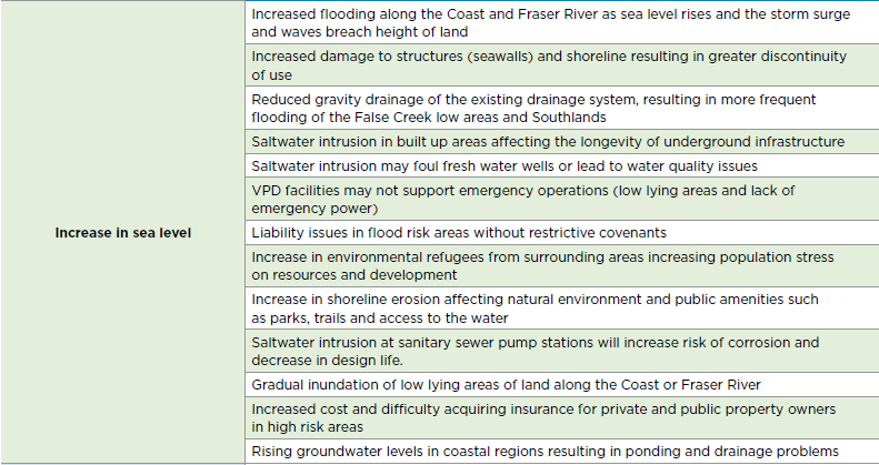
(City of Vancouver 2011)
Impacts of Sea Level Rise to the City of Vancouver
 (Vancouver Climate Adaptation Strategy 2011)
Future flooding caused by sea level rise is projected to impact heavily on a number of areas, these include
City Infrastructure:
Major city infrastructure is expected to be impacted by flooding as result of sea level rise, these may include
-Sewerage system
-Buildings & infrastructure
-Energy systems
-Transportation systems
-Water distribution
-Telecommunications
Economy/Assets
Direct economic costs of flooding caused by sea levels can be in the form of damages to buildings and infrastructure.
Vancouver is a major port city with large amounts of cargo being transported and transferred, damages to its ports as well as other transportation & telecommunication infrastructure can cause indirect economic impacts include loss of potential earnings, disruption of operations etc.
Environment
Sea level rise and flooding will also cause Damages to freshwater supplies, vegetation and wildwife within the eco-system.
Identification of High Risk Areas
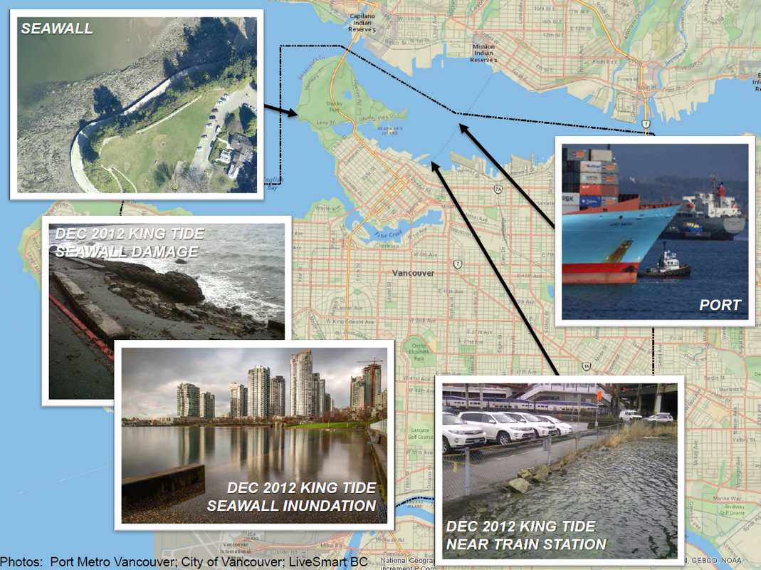
(North 2013)
Flood Modelling Results
The 2 Flood Maps below shows the projected flooding levels in the event of a storm surge at high tide.
The model on the left shows that the level of flooding within Vancouver's inner harbour areas in the event of a storm surge complemented by high tide in 2020.
The model on the left shows the impact of a 1 m in sea level rise that is projected by 2100, complemented by a same event, the rise of 1 m in sea level

(Badelt 2014)
|

(Badelt 2014)
|
Identification of High Risk Areas

(Badelt 2014)
Using sophisticated computer modelling, the City was able to identify specific areas within the City that are most vulnerable. The identification of these areas will assist in the City's adaptation planning decisions.
The above Flood Map shows the areas affected in the worst case scenario in the event of a 1 in 500 year and 1 in 10,000 year storm surge based on a 1m sea level rise by the year 2100.
The graph below illustrates the financial loss that will occur as result of this event.
The above Flood Map shows the areas affected in the worst case scenario in the event of a 1 in 500 year and 1 in 10,000 year storm surge based on a 1m sea level rise by the year 2100.
The graph below illustrates the financial loss that will occur as result of this event.
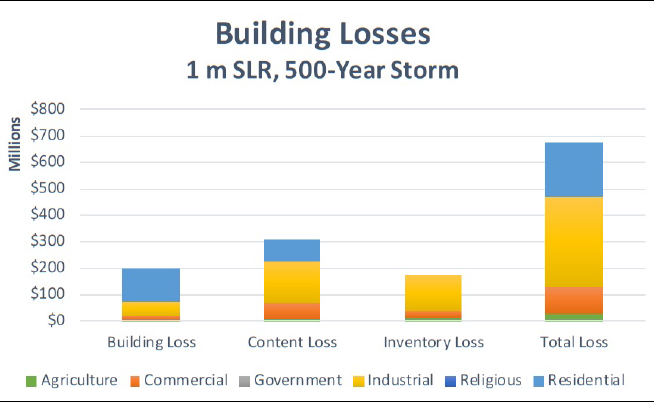
(Ebbwater Consulting 2013)
Reference List
Badelt, B. 2014, Science and Policy on the Ground: Implementing Vancouver’s Adaptation Strategy, PNW Climate Science Conference September 9, 2014
City of Vancouver 2012, Climate Change Adaptation Strategy, viewed 21 August 2015 < http://vancouver.ca/files/cov/Vancouver-Climate-Change-Adaptation-Strategy-2012-11-07.pdf>
Ebbwater Consulting 2013, City of Vancouver Coastal Flood Risk Assessment, viewed 30 August 2015, <http://www.ebbwater.ca/wp/projects/vancouver-coastal-flood/>
North, S. 2013, Sea Level Rise in the City of Vancouver: Mapping Coastal Flood Risk, viewed 30 August 2015, <http://www.proceedings.esri.com/library/userconf/proc15/papers/332_634.pdf>
Vancouver Sun 2013, Coastal communities plan for rising water levels (Part 2 of 3) viewed 20 August 2015, <http://www.vancouversun.com/business/2035/Coastal+communities+plan+rising+water+levels+Part/7673981/story.html#ixzz3kNGLyiA8>
