Case Relevance
Rotterdam is a delta city at the forefront of adaptive strategies to global climate change, in particular the city is at risk of water inundation from rising sea levels, storm surges and heavy rainfall. It shares strong similarities with the City of Sydney in its economical & cultural importance to its region, its location as a coastal port city and the opportunities it derives from its relationship to water (C40 Cities Climate Leadership Group, 2015) (Delta C40 Cities Network- Connecting Cities, 2014).
Geography
Rotterdam is a coastal city situated in province of South Holland, situated at the delta of the rivers, Scheldt, Rhine and Meuse, approximately 35 kilometers south of the North Sea. The city provides strategic deep water port facilities, rail, road, air and water transit ways and it is an important trade gateway into Europe with an annual shipment of 400 million tonnes of cargo (City of Rottderdams Regional Steering Committee, 2009). The next largest European port is Antwerp with a annual shipment of 189.5 million tonnes in 2008 (RotterdamWorldPortCity, 2009) and in comparison to the worlds largest port of Shanghai which ships 582 million tonnes in 2008 (RotterdamWorldPortCity, 2009).
The city covers an area of 319.35 km, split between land areas (205.90 km), water (113.45 km) and its port stretches 40 km . Approximately one third of the city area comprises of water ways. The city has a housing stock of 289,337 dwellings with a housing density of 1,402/ km (CityofRotterdam, 2012).
Economy
The city is Europe’s largest seaport and a major international shipping centre (within the top 10 world ports (RotterdamWorldPortCity, 2009)) which services the Netherlands and the industrial cities along the Ruhr. Ships access the city via the Nieuwe Waterweg and the port infrastructure includes, Europoort, crude oil refineries, gas pipelines, food production plants, shipyards and petrochemical facilities. Cargo from world markets are processed in Rotterdam and distributed via its multi-modal transport network to through to the regional hinterland (City of Rottderdams Regional Steering Committee, 2009).
The city’s economy is largely driven by the logistics sector (inclusive of industry, wholesale, transport, storage and transshipment) which contributes approximately 10,257 million euros out of a total economy of 24,238 million euros. The port and industrial complex employs 73,529 people from its total workforce of 321,311 people in 2012 (CityofRotterdam, 2012) (Marianne Schouten, 2011).
The heavy reliance on its port-related business and industrys has seen the city invest in developing its port facilities with the construction of Maasvlakte 2, comprising 1000 ha of industrial facilities built onto deep water and 750 ha of nature reserves. Rising sea levels and water inundation threaten the cities long term viability as a Europe’s largest port and has continual invested in expanding its sea defenses.
Culture
The city is a cultural metropolis with a demographic of 170 nationalities, a regional population inclusive of the Hague metropolitan of 2.2 million (IndexMundi, 2014) and a city population of 616, 456 people (2,942/km) (RotterdamWorldPortCity, 2009) (CityofRotterdam, 2012). Rotterdam has a cultural and historic heritage tied with water and possesses many internationally renown learning institutions and a highly skilled workforce (City of Rottderdams Regional Steering Committee, 2009).
Vulnerability
As one of Europe’s lowest lying cities with some city areas 4-7 meters below sea level (Keeton, 2013), Rotterdam is considered to be extremely vulnerable to rising sea levels and has heavily invested in its sea defenses. A major storm surge in 1953 (a 1:300 year risk) flooded Rotterdam and one third of Dutch coastal areas (135,000 ha of land) (d’Angremond, 2003), with tidal levels rising 3.8 meters causing 1,800 casualties, 72,000 people displaced (Keeton, 2013) and exposed Rotterdam’s vulnerability to water inundation, since then the city has expanded its water infrastructure with the delta project beginning after 1953 and completed in 2010 comprising a multi-tiered system of primary defenses, sea walls, dykes, levies and secondary water ways.
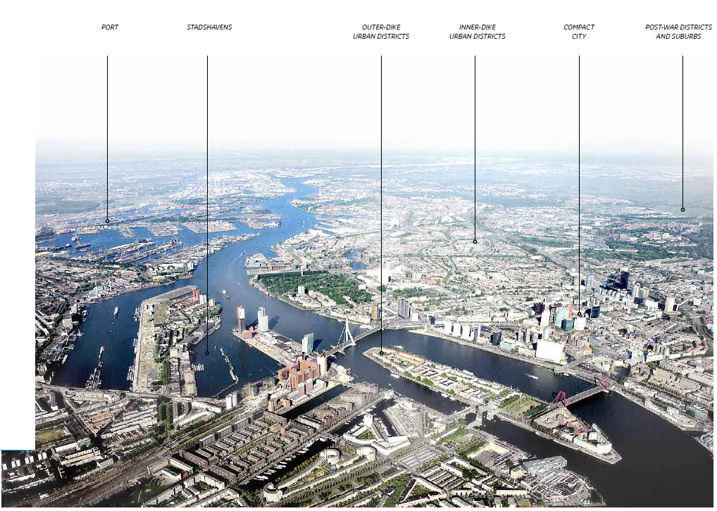
The city is particularly vulnerable to rising sea levels and river flow. The extent of rising sea levels is uncertain however predictions show a probability of a 85 cm rise by the year 2100, where changes of 60cm would increase the risk from flooding from a 1 in 50 year scenario to annual event. Important infrastructure (power stations, major transport routes, gas pipelines) in the outer dyke area and disruptions to business are all vulnerable to damage (Rotterdam Climate Initiative, 2014). A rise in sea levels will also cause greater disruptions to river flow and increase risk of inner-dike areas.
Similarities to Sydney
The city of Sydney shares many similarities with the City of Rotterdam in regards to the global issue of dealing with climate change and the effects of rising sea levels. Rotterdam like Sydney has three levels of government, central, provincial and municipal. The city is also a major port, industrial, economic, knowledge & cultural centre of the region.
Similar to the challenges faced by the City of Sydney Council, Rotterdam municipal council is responsible for a wide number of policy implementation including local planning, development & the environment and follows the general framework of the central government. Both Rotterdam and Sydney have limited means of raising revenue through local taxation and must work together will all its stakeholders to implement new policies and ideas.
Both cities will be affected by climate change and face extensive uncertainty to the extent & speed of rising sea levels and have responded with different strategies to climate adaptation & mitigation.
Rotterdam is a delta city at the forefront of adaptive strategies to global climate change, in particular the city is at risk of water inundation from rising sea levels, storm surges and heavy rainfall. It shares strong similarities with the City of Sydney in its economical & cultural importance to its region, its location as a coastal port city and the opportunities it derives from its relationship to water (C40 Cities Climate Leadership Group, 2015) (Delta C40 Cities Network- Connecting Cities, 2014).
Geography
Rotterdam is a coastal city situated in province of South Holland, situated at the delta of the rivers, Scheldt, Rhine and Meuse, approximately 35 kilometers south of the North Sea. The city provides strategic deep water port facilities, rail, road, air and water transit ways and it is an important trade gateway into Europe with an annual shipment of 400 million tonnes of cargo (City of Rottderdams Regional Steering Committee, 2009). The next largest European port is Antwerp with a annual shipment of 189.5 million tonnes in 2008 (RotterdamWorldPortCity, 2009) and in comparison to the worlds largest port of Shanghai which ships 582 million tonnes in 2008 (RotterdamWorldPortCity, 2009).
The city covers an area of 319.35 km, split between land areas (205.90 km), water (113.45 km) and its port stretches 40 km . Approximately one third of the city area comprises of water ways. The city has a housing stock of 289,337 dwellings with a housing density of 1,402/ km (CityofRotterdam, 2012).
Economy
The city is Europe’s largest seaport and a major international shipping centre (within the top 10 world ports (RotterdamWorldPortCity, 2009)) which services the Netherlands and the industrial cities along the Ruhr. Ships access the city via the Nieuwe Waterweg and the port infrastructure includes, Europoort, crude oil refineries, gas pipelines, food production plants, shipyards and petrochemical facilities. Cargo from world markets are processed in Rotterdam and distributed via its multi-modal transport network to through to the regional hinterland (City of Rottderdams Regional Steering Committee, 2009).
The city’s economy is largely driven by the logistics sector (inclusive of industry, wholesale, transport, storage and transshipment) which contributes approximately 10,257 million euros out of a total economy of 24,238 million euros. The port and industrial complex employs 73,529 people from its total workforce of 321,311 people in 2012 (CityofRotterdam, 2012) (Marianne Schouten, 2011).
The heavy reliance on its port-related business and industrys has seen the city invest in developing its port facilities with the construction of Maasvlakte 2, comprising 1000 ha of industrial facilities built onto deep water and 750 ha of nature reserves. Rising sea levels and water inundation threaten the cities long term viability as a Europe’s largest port and has continual invested in expanding its sea defenses.
Culture
The city is a cultural metropolis with a demographic of 170 nationalities, a regional population inclusive of the Hague metropolitan of 2.2 million (IndexMundi, 2014) and a city population of 616, 456 people (2,942/km) (RotterdamWorldPortCity, 2009) (CityofRotterdam, 2012). Rotterdam has a cultural and historic heritage tied with water and possesses many internationally renown learning institutions and a highly skilled workforce (City of Rottderdams Regional Steering Committee, 2009).
Vulnerability
As one of Europe’s lowest lying cities with some city areas 4-7 meters below sea level (Keeton, 2013), Rotterdam is considered to be extremely vulnerable to rising sea levels and has heavily invested in its sea defenses. A major storm surge in 1953 (a 1:300 year risk) flooded Rotterdam and one third of Dutch coastal areas (135,000 ha of land) (d’Angremond, 2003), with tidal levels rising 3.8 meters causing 1,800 casualties, 72,000 people displaced (Keeton, 2013) and exposed Rotterdam’s vulnerability to water inundation, since then the city has expanded its water infrastructure with the delta project beginning after 1953 and completed in 2010 comprising a multi-tiered system of primary defenses, sea walls, dykes, levies and secondary water ways.
The city is particularly vulnerable to rising sea levels and river flow. The extent of rising sea levels is uncertain however predictions show a probability of a 85 cm rise by the year 2100, where changes of 60cm would increase the risk from flooding from a 1 in 50 year scenario to annual event. Important infrastructure (power stations, major transport routes, gas pipelines) in the outer dyke area and disruptions to business are all vulnerable to damage (Rotterdam Climate Initiative, 2014). A rise in sea levels will also cause greater disruptions to river flow and increase risk of inner-dike areas.
Similarities to Sydney
The city of Sydney shares many similarities with the City of Rotterdam in regards to the global issue of dealing with climate change and the effects of rising sea levels. Rotterdam like Sydney has three levels of government, central, provincial and municipal. The city is also a major port, industrial, economic, knowledge & cultural centre of the region.
Similar to the challenges faced by the City of Sydney Council, Rotterdam municipal council is responsible for a wide number of policy implementation including local planning, development & the environment and follows the general framework of the central government. Both Rotterdam and Sydney have limited means of raising revenue through local taxation and must work together will all its stakeholders to implement new policies and ideas.
Both cities will be affected by climate change and face extensive uncertainty to the extent & speed of rising sea levels and have responded with different strategies to climate adaptation & mitigation.
